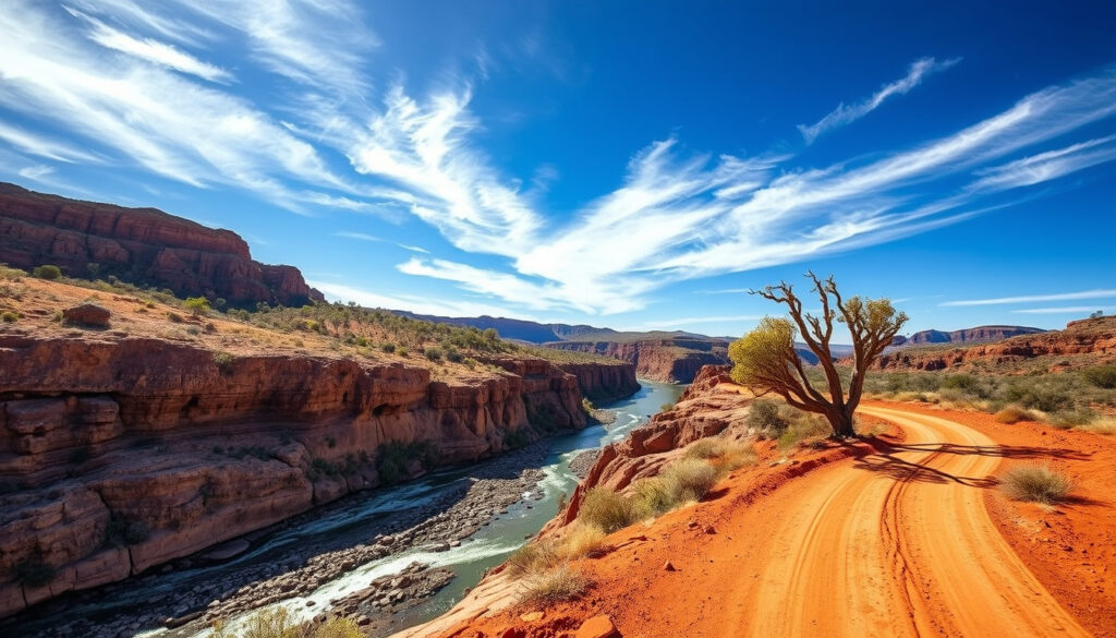
Gibb River Road Guide: Itinerary, Conditions & Tips 2026
The Gibb River Road stretches 660 km across Western Australia’s Kimberley region, connecting Derby to Kununurra through some of the country’s most rugged terrain. This iconic route rewards travelers with dramatic gorges and ancient landscapes, but it demands serious preparation. Fuel planning becomes critical when roadhouses sit hundreds of kilometers apart and petrol proves harder to source than diesel. This guide covers everything you need to know before you go — from seasonal access windows to fuel-stop logistics and vehicle requirements.
Length: 660 km · Location: Kimberley region, Western Australia · Road type: Mostly unsealed gravel · Best season: Dry season (May to October) · Endpoints: Derby to Kununurra
Quick snapshot
- 660 km of mostly unsealed gravel road (Defender Adventure Safety Guide)
- 4WD essential for all vehicle types (Main Roads Western Australia)
- Open dry season only: May to October (Defender Adventure)
- Carry jerry cans for extra fuel due to side trips to attractions (Australia’s North West)
- Petrol harder to find than diesel; no LP gas available (Kimberley Australia)
- Mt Barnett Roadhouse is the only stop offering unleaded fuel along the main Gibb River Road (Australia’s Boab Country)
- Derby to Imintji: 227 km (Australia’s North West)
- Imintji to Mt Barnett: 80 km (Australia’s North West)
- High-clearance 4WD mandatory (Main Roads Western Australia)
- Not recommended for standard caravans; off-road caravans or camper trailers perform better (Club 4X4)
- Spare tires, recovery gear, and extra water essential (Club 4X4)
- Road conditions vary from graded gravel to rough corrugated sections (Defender Adventure Safety Guide)
- Wet season (November to April) makes road impassable due to flooding (Defender Adventure Safety Guide)
- Conditions constantly changing; check Main Roads WA for updates (Main Roads Western Australia)
- Follow half-tank rule: refuel when half empty on Gibb River Road (Defender Adventure)
- Stock up in Broome, Derby, Kununurra supermarkets before trip (Australia’s North West)
How long does it take to do the Gibb River Road?
Driving the Gibb River Road requires realistic time expectations. The 660 km route takes most travelers 2–3 days one-way without stops, but a full itinerary of 7–14 days lets you experience the gorges, gorges, and stations along the way.
Driving time estimates
The Gibb River Road connects Derby (southwest) to Kununurra (northeast) across 660 km of challenging terrain. Without side trips, expect 8–10 hours of actual driving time spread over 2–3 days. The road surface alternates between graded gravel and rough corrugated sections, so progress is slower than highway speeds suggest.
- Derby to Imintji Store: 227 km (approximately 3–4 hours)
- Imintji to Mt Barnett Roadhouse: 80 km (approximately 1–2 hours)
- Mt Barnett to Mt Elizabeth Station: 39 km (approximately 1 hour)
- Mt Elizabeth to El Questro: 281 km (approximately 4–5 hours)
- El Questro to Kununurra: 81 km (approximately 1–2 hours)
Factors affecting duration
Several variables determine how long your Gibb River Road adventure takes:
- Road conditions: Corrugated sections require reduced speeds (40–60 km/h average)
- Side trip detours: Windjana Gorge, Bell Gorge, and Manning Gorge add 50–100 km each way
- Time of year: Late dry season (September–October) may have dustier conditions
- Vehicle type: Loaded 4WDs with trailers travel significantly slower
“The Gibb River Road can be open one day and closed the next, depending on weather or crews fixing damage.” — Defender Adventure
Is there fuel on the Gibb River Road?
Fuel availability on the Gibb River Road is limited and requires careful planning. Petrol is significantly harder to find than diesel, and no LP gas is available at any roadhouse.
Fuel stop locations
The main fuel stops along the Gibb River Road include:
| Location | Fuel types | Operating hours | Distance from Derby |
|---|---|---|---|
| Derby | Diesel, Unleaded | 24/7 (fuel stations) | 0 km |
| Mt Hart Wilderness Lodge | Diesel, Petrol | Varies seasonally | 189 km |
| Imintji Store | Diesel only | 8:00 am–5:00 pm daily | 227 km |
| Mt Barnett Roadhouse | Diesel, Unleaded (pre-order) | 8:00 am–5:00 pm daily | 307 km |
| Mt Elizabeth Station | Diesel only | Varies seasonally | 346 km |
| El Questro Station | Diesel, Petrol | 7:00 am–5:00 pm daily | 627 km |
| Kununurra | Diesel, Unleaded | 24/7 (fuel stations) | 660 km |
| Drysdale River Station (Kalumburu Road) | Diesel, Petrol, Tyre repairs | Varies seasonally | 478 km |
Fuel availability fluctuates by season and demand. Use the FuelWatch app or visitor centres to confirm current fuel availability before and during your trip.
Tips for fuel management
- Follow the half-tank rule: refuel when your tank reaches half capacity
- Carry jerry cans for extra fuel, especially for side trips to attractions
- Pre-order unleaded petrol at Mt Barnett Roadhouse as supplies are limited
- Expect higher prices at remote roadhouses: Diesel AUD 2.35–2.40/L at Imintji and Mt Barnett vs. AUD 2.10/L in Derby
Where do you start the Gibb River Road?
The Gibb River Road has two primary access points: Derby in the southwest and Kununurra in the northeast. Most travelers prefer starting from Derby for a logical scenic progression through the Kimberley.
Derby or Kununurra start
Derby offers full services including supermarkets, fuel stations, accommodation, and mechanical workshops. This western start point lets you travel “up” the road, potentially benefiting from fresher road conditions earlier in your journey. Kununurra provides similar services at the eastern end but is slightly more remote.
Direction recommendations
Traveling west to east (Derby to Kununurra) aligns with most tour logistics and allows you to camp at established locations like El Questro as darkness falls. The route passes through progressively dramatic landscape, from the boab-studded plains near Derby to the rugged Cockburn Range near Kununurra.
“Travellers are advised to carry jerry cans with extra fuel.” — Australia’s North West
When can you do the Gibb River Road?
The Gibb River Road operates on a strict seasonal schedule due to the Kimberley wet season. The road is typically open from May to November, with closures from November through April when flooding makes passage impossible.
Seasonal opening
The dry season (May to October) represents the ideal window for Gibb River Road travel:
- May: Road typically opens after wet season repairs; conditions can be muddy early in the month
- June–August: Peak season with best road conditions and full services at roadhouses
- September–October: Late dry season; hotter temperatures (35–40°C) and dustier conditions
- November: Road begins closing; unpredictable conditions as wet season approaches
2026 updates
Check Main Roads Western Australia for real-time road status before your 2026 trip. The Gibb River Road can be open one day and closed the next following wet weather or repair work.
“
More related posts
 What Is Vaping? Definition, How It Works & Health Risks
 Kirk Pengilly: INXS Band Member, Wife, Net Worth, Illness
 Kmart Shoe Storage – Best Racks Organizers 2024
 The Running Man 2025: Reviews, Cast, Flop to Streaming Hit
 Jessica Osbourne: Who She Is, Why She Skipped Ozzy’s Funeral
 Phillip Island Wildlife Park: Hand-Feed Kangaroos, Tickets, Hours
 Romance in KPop Demon Hunters: Character Guide & Kiss Mystery
 Nikolaj Coster-Waldau: Languages, Net Worth, Facts